From the Archives – A Warwickshire Eclipse by Mike Frost
With all the excitement about the recent eclipse continuing to dominate our club’s What’s App Channel, it seems like a good time to dip into the archives and revisit an article by Mike Frost on the 1736 (or 1737!) solar eclipse observed from Warwickshire. So, for this month’s From The Archives feature, we go back to MIRA 69 from 2004…Enjoy!
A Warwickshire Eclipse By Mike Frost
During the Easter holidays I paid a visit to the Warwickshire County Record Office, at Priory Park in Warwick. I was hoping to find out information about the Rugby Literary and Scientific Institution, founded in the 1830’s. The early members included Matthew Arnold, the famous headmaster of Rugby School and Joseph Hooley Lockyer, father of Rugby’s eminent astronomer, Joseph Norman Lockyer. The biographies of Norman Lockyer make mention of the minute books from the meetings of the Literary and Scientific Institution, and I was hoping to find these in the Record Office.
I didn’t succeed. The only relevant document I could find was an (uninspiring) accounts book dating from the 1850’s, some time after the Lockyer family had departed Rugby. There was also a note, signed by Norman Lockyer, apologising for being unable to attend some function (I couldn’t decipher what). However, my visit to Priory Park was by no means wasted, as I made several other serendipitous discoveries. For example, there was an almanac for the year 1665, owned by one William Gosnall, and filled with his daily scribbles. On the 3rd April 1665, he records seeing, at 4am, a comet which “hath been seen by many persons in & abought this city of London”
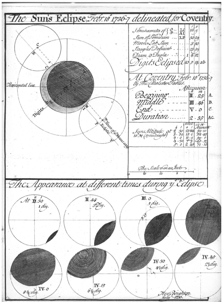
Best of all, however, was the beautiful eclipse map that accompanies this article — “The Sun’s Eclipse, Febr 18th 1736-7, delineated for Coventry”. Please take a moment to look at the map above — it repays study. The original, rather larger than A4 size, is in ink and watercolour (which adds to the appeal).
In the top left hand corner, the path of the Moon across the Sun is shown. Where the two are superimposed, the Moon is darker shaded. It is clear that, first, the Moon’s apparent size is less than the Sun’s — so this was not a total eclipse. Moreover, from Coventry the eclipse was not central — there was never a point in time at which the Moon was completely super-imposed on the Sun. We’ll see later on that the eclipse was central when viewed from further north, producing an annular eclipse.
In the top right hand corner are various elements of the calculation. The Sun was predicted to have a radius of 16 minutes and 9 seconds of arc; Sun and Moon together 30′ 29″; however the path of the Moon was offset by 3′ 30″ from the Sun’s centre. The upshot was that, if the Sun’s diameter were divided into twelve digits, just over ten-and-a-half of these would be obscured by the Moon at the time of maximum eclipse.
Next come the local times for observing from Coventry, and the Sun’s altitude and azimuth at these times. This was an afternoon eclipse, beginning at 2:25 pm and ending at 5:00 pm, a duration of 2 hours 35 minutes. The date also deserves comment. First of all, it is prior to the change from Julian to Gregorian calendar in 1752, so 11 days have to be added to give a date in the new (current) style, of March 1st, which is when the eclipse is recorded in some reference books. Note also that the year is described as 1736-7, as the new year was considered to begin on March 25th (this is why our tax year still begins on April 5th, 11 days on from March 25th).
Finally, at the bottom of the map is “The appearance at different times during ye eclipse”, showing the slow progress of the Moon across the solar disk. Hidden in amongst these is the signature of (I presume) the map’s author, Hen. Beighton, July 1736. So this was a predictive map, produced beforehand to show the expected path of the eclipse, rather than a description of what happened after the event.
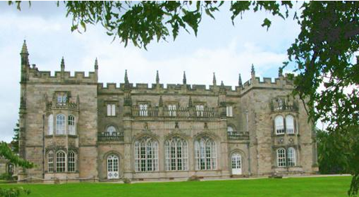
In the Record Office, I pored over the map for some time, struck as much by its beauty as a document as by the astronomy it features. But of course the map suggests many questions. Who was Mr. Henry Beighton? Who did he produce the map for? Was the map accurate? And was the eclipse observed, from Coventry or anywhere else? I can answer one question with some certainty. The map is in the papers of Sir Roger Newdigate, of Arbury Hall, Nuneaton. I’m sure many of you will have visited this lovely stately home, situated to the south Arbury Hall west of Nuneaton. It features a stable with a frontage designed by Sir Christopher Wren in 1674, one of his few commissions outside London. However, Arbury Hall as we know it today was mostly modelled by Sir Roger Newdigate during the eighteenth century. He inherited Arbury Hall at the age of 14 in 1734, only 3 years before the eclipse.
Other papers in the Newdigate collection, presumably produced by Newdigate himself, show that he struggled to grasp the fundamentals of astronomy. There are pages of exercises in his papers, showing the solar system and reproducing basic propositions from Isaac Newton’s Principia Mathematica, for example the parabolic motion of a projectile under gravity, or the tidal bulge caused by the attraction of the Moon. From a viewpoint three centuries on, these are very straightforward calculations, the kind of thing you would find in any physics textbook. But don’t forget that Principia had been published less than sixty years previously, and so the details of the theory of gravity would be as unfamiliar to people then as, say, relativity or quantum mechanics are to us today.
In the early part of the eighteenth century, astronomy was a hot topic. The scientists of the previous century, from Galileo and Kepler, through Jeremiah Horrocks and culminating with Isaac Newton, had solved the theory of planetary motion pretty much comprehensively (it would be another 180 years before Einstein came up with a better theory, which mopped up the tiny residual errors in the motion of Mercury). The importance of astronomical calculations to marine navigation had led to the establishment of the Greenwich Observatory and the appointment of John Flamsteed as the first Astronomer Royal in 1675.
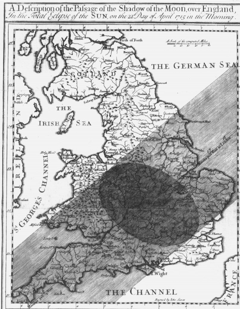
Added to these momentous events was an extraordinary co-incidence. In the first quarter of the eighteenth century, southern England enjoyed not one but two total solar eclipses within the space of ten years, in April 1715 and May 1724. To understand how rare this is, consider that England has had only two total eclipses in the succeeding three centuries — in 1927 and in 1999. In many ways, the timing could not have been more fortuitous. A century before, these eclipses might have been predicted approximately (the Saros cycle, where eclipses approximately repeat every 54 years, had been known for millennia). But now mathematicians had the means to predict the path of these two eclipses with unprecedented accuracy.
A number of astronomers took up the challenge, but the most successful attempt was by Edmund Halley, who produced a famous map predicting the track of totality, across southern England, including London. April 22nd 1715 was a clear day, and the total eclipse was widely observed. Halley described the solar corona, “a luminous ring, of a pale whiteness, or rather pearl colour, a little tinged with the colours of the Iris, and concentric with the Moon”. After the eclipse, Halley collected accounts of the eclipse and produced a more accurate map of the eclipse track. The 1715 revised map is the most accurate path of a total eclipse track prior to the twentieth century (the next step in accuracy occurred in 1925 when the path of totality crossed over Manhattan, enabling the totality track to be narrowed down to individual blocks in the city), and is of great use to scientists who want to estimate how much the Earth’s rotation period has changed by during the last three centuries.
The 1724 eclipse was not total over London (the track crossed South Wales and the south-west of England) and was not as well observed as the 1715 eclipse. Dr Stukeley, the noted antiquary, observed it from Haraden Hill, near Salisbury, and reported that the spectacle was “beyond all that he had ever seen or could picture to his imagination the most solemn”.
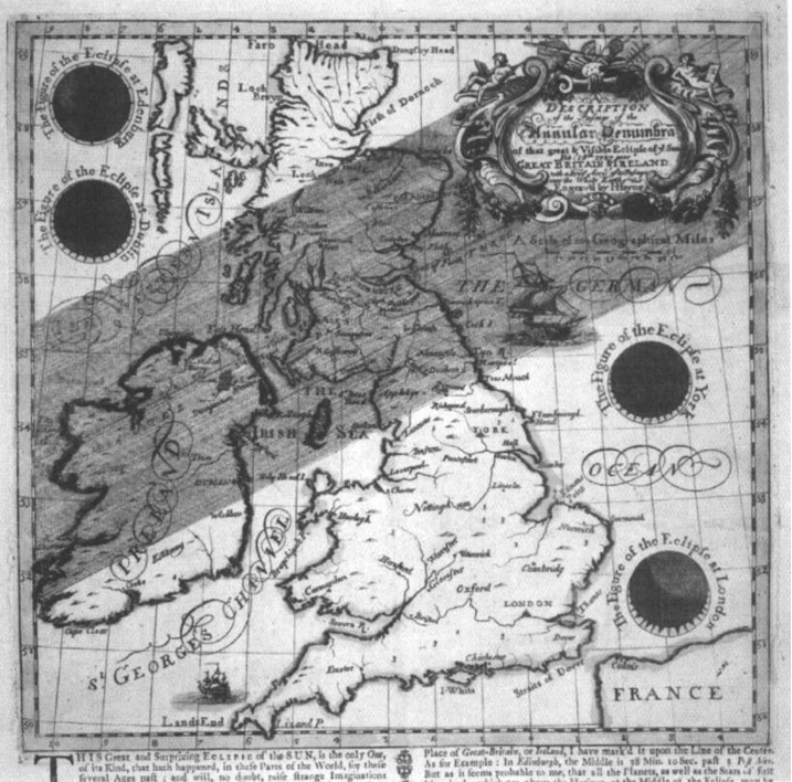
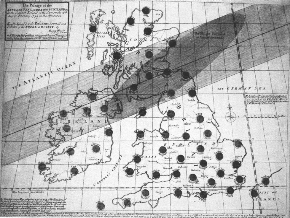
Halley was by no means the only astronomer to produce eclipse maps. I’ve reproduced several illustrations from Geoff Armitage’s lovely book on eclipse maps, which I reviewed for Astronomy Now a few years ago (I liked it!).
The maps fall in to two general types — eclipse track maps, such as Halley’s, which show all the locations where an eclipse will be total or annular, and maps such as Beighton’s showing the view to be seen at a particular location. Both types of map were produced for the 1737 eclipse. George Smith, of York, produced a rather wonky map showing the entire track of the eclipse across the Atlantic and into Europe. John Haynes and Thomas Wright produced rather less ambitious but more precise maps showing the track across Britain. Both Haynes and Wright predicted that the 1737 eclipse would be annular over the far north of England and lowland Scotland. It is clear that Henry Beighton’s predictions of a deep partial eclipse were accurate. So, Henry Beighton was one of several mathematicians to predict the circumstances of the annular eclipse of 1737. Do we know anything more about him? I hadn’t heard of him prior to researching this article, but he turns out to be a remarkable and versatile man. He was born on 20th August 1687 (some authors say 1686) in Chilvers Coton, a hamlet to the south of Nuneaton. His family were yeomen, holders of land in Griff, between Bedworth and Nuneaton. So Beighton was a landowner, but not of substantial estates. Fortunately he was able to supplement his less than impressive estate income with an impressive variety of other accomplishments.
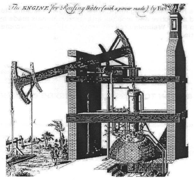
In 1713, Beighton took over the editorship of The Ladies’ Diary on the death of his friend John Tipper, a Coventry schoolmaster. The Ladies’ Diary was a journal that featured a variety of mathematical features and puzzles, often set by Beighton himself. Beighton, who edited the magazine anonymously for many years, was determined to produce a journal of more substance than the almanacs of the day, which were more Old Moore’s than Whittaker’s in tone. Under Beighton’s editorship The Ladies’ Diary became one of the leading mathematical journals of the day. Beighton’s skills were not just theoretical. In 1711, he suggested that the new technology of the steam engine could be used in local collieries to pump water out of the mines. In April 1714, three Midlands entrepreneurs, Richard and Stonier Parrott
and George Sparrow, employed Thomas Newcomen, builder of the first industrial steam engine, to build his second steam engine for the Griff colliery, on land in the Newdigate estates. Henry Beighton may well have been involved in this project; certainly in 1717 Beighton himself built a Newcomen steam engine at Oxclose Colliery, Washington Fell, in County Durham. A picture of this engine, drawn by Beighton, still exists, entitled “The Engine for Raising Water (with a power made) by Fire”. It is the earliest known drawing of a steam engine. Also in 1717, Beighton made calculations on the diameter of pump barrel and steam cylinder needed to pump water from different depths. These were published in The Ladies’ Diary. In 1720 Henry Beighton was elected to a Fellowship of the Royal Society. Between 1722 and 1725, Beighton surveyed the county of Warwickshire in unprecedented detail, to draw one of the first county maps produced in England, and certainly the most accurate to that time. Beighton used trigonometrical surveying techniques, common in France, but new to England. In the pages of The Ladies’ Journal, he advertised his map for several years, hoping to finance his surveying and printing costs by advance orders — the map was finally published in 1729.
Around this time, Beighton began a business relationship with Sir Richard Newdigate, Roger Newdigate’s father. It isn’t clear to me exactly what this entailed — one source (Rolt & Allen) suggests that Henry Beighton, in partnership with his mother, leased collieries from Newdigate senior; another author (White) cites a report from Beighton to Lady Newdigate suggesting that collieries should be closed down. However, it does appear that Beighton acted as friend and advisor to Newdigate senior.
So, we know that Henry Beighton was an accomplished surveyor and engineer. In the Newdigate papers, there are also a ground plan and a prospect (both in poor condition) of Arbury Hall, drawn by Beighton in 1708. Additionally, there are notes by Beighton on The Use of the Moon’s Instrument and The Use of the Quadrant — both practical instructions for surveying the heavens. So perhaps it’s no surprise that Beighton should turn his hand to mapping the eclipse for Roger, the son of his late friend Richard Newdigate.
At the time of the 1737 eclipse Henry Beighton was forty-nine years of age, a self-educated man who had risen from relatively low social standing to achieve business success, engineering brilliance, editorship of a respected mathematical journal, and a reputation as the finest surveyor in the country. Roger Newdigate was sixteen years old, recently installed as the lord of Arbury Hall, a precocious (one suspects) young man with big ideas and the world at his feet. One can imagine Beighton securing the gratitude of his aristocratic young friend with the gift of a map to trace the forthcoming eclipse.
Roger Newdigate went on to study at Oxford and make a Grand Tour of Europe, before becoming a Member of Parliament. Despite representing Middlesex, he spent all but three months of each year in Arbury Hall, his pride and joy and in later years was increasingly reluctant to leave the estate. He was lord of the manor at Arbury for seventy-two years, and completely remodelled the hall, room by room, producing one of the finest examples of Gothic architecture in Britain.
Henry Beighton, on the other hand, died only six years after the eclipse, in 1743, and was buried at Chilvers Coton.
One final question remains — what was the weather like on eclipse day? The annular eclipse was certainly seen from Scotland. The Scottish mathematician Colin Maclaurin reported that “A little before the annulus was complete, a remarkable point or speck of pale light appeared near the middle part of the Moon’s circumference that was not yet come upon the disc of the Sun. . . During the appearance of the annulus the direct light of the Sun was still very considerable, but the places that were shaded from this light appeared gloomy. There was a dusk in the atmosphere, especially towards the north and east. In those chambers that had not their lights westwards the obscurity was considerable. Venus appeared plainly, and continued visible long after the annulus was dissolved, and I am told that other stars were seen by some”.
Alas, I have no idea what happened from Warwickshire! I made a second visit to the County Record Office when I spotted that among the Newdigate papers, there is also a diary covering the period 1736-1743. Unfortunately, this diary turns out to be a very perfunctory record of the period, with no entries at all for February 1737. It would appear that Newdigate was at Arbury Hall during this time; the entry for March 1st 1737 records a move from Arbury to Astley, a nearby manor.
There is no clue as to whether Newdigate or Beighton attempted to observe the eclipse, or if the weather helped or hindered them. But I hope Henry Beighton and Roger Newdigate saw their eclipse!
Acknowledgements:
The descendants of the Newdigates who kindly gave permission to reproduce the eclipse map from the family archives. The staff of the Warwickshire Record Office for their assistance. Chris Hicks of Rugby Local History Group (a colleague at work) who educated me on the many accomplishments of Henry Beighton.
Sources / Further Reading
Henry Beighton’s eclipse map has classification CR136/B2551 in the Warwickshire Records; the prospect of Arbury Hall is CR1199/70, the ground plan is CR270/7, and Beighton’s notes on Lunar and Quadrant measurements are CR136/B3026. Newdigate’s diary is CR136/ B3015/1, and William Gosnall’s journal has classification CR2133/1.
All other eclipse maps appear in “The shadow of the moon (British solar eclipse mapping in the eighteenth century)” — Geoff Armitage (Map Collector Publications, 1997) Beighton’s picture of the early steam engine is reproduced from “The Steam Engine of Thomas Newcomen” — L.T.C.Rolt & J.S.Allen (Moorland, 1997)
The story of the Griff colliery appears in “Men and Mines in Warwickshire” — A.W.A.White (Coventry Branch of the Historical Association, 1970)
The detail from Beighton’s Warwickshire map appears from “Maps and Plans for the Local Historian and Collector” — David Smith (Batsford)
An account of Beighton’s attempts to sell his map is given in “Marketing Mathematics in Early Eighteenth-Century England: Henry Beighton, Certainty, and the Public Sphere” — Shelley Costa (History of Science xl, 2002)
The Halley, Stukeley and Maclaurin quotes are taken from “UK Solar Eclipses from Year 1” — Sheridan Williams (Clock Tower Press, 1996)
There is a concise history of Arbury Hall at www.heritage.me.uk/houses/arbury.ht